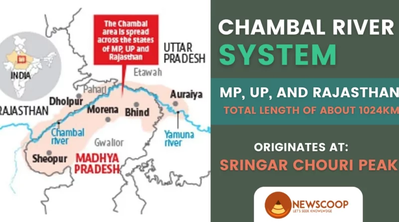
The Chambal River is one of the major rivers in India, flowing through the states of Madhya Pradesh, Rajasthan, and Uttar Pradesh. It is an important tributary of the Yamuna River and ultimately drains into the Bay of Bengal. The river originates from the Vindhya mountain range in Madhya Pradesh and travels a length of approximately 1024 kilometers before merging with the Yamuna River.
The Chambal River is known for its unique and diverse ecosystem, which supports a wide variety of flora and fauna, including several endangered species.
| River | Chambal River |
| States Flowing Through | Madhya Pradesh, Rajasthan, Uttar Pradesh |
| Boundary Formation | Forms boundary between Rajasthan and Madhya Pradesh |
| Length | 1024 km |
| Origin | Sringar Chouri peak, Vindhyan Range, Madhya Pradesh |
| Confluence | Joins Yamuna River in Etawah, Uttar Pradesh |
| Landmark Confluence | Pachnada near Bhareh, Uttar Pradesh (Chambal, Kwari, Yamuna, Sind, and Pahuj rivers) |
| Major Tributaries | Banas, Mej (left bank), Parbati, Kali Sindh, Shipra (right bank) |
| Dams | Gandhi Sagar Dam, Rana Pratap Sagar Dam, Jawahar Sagar Dam, Kota Barrage |
Geographical Features of Chambal River
The Chambal River, renowned for its pristine beauty and unique geography, possesses several distinctive features. Here are some notable geographical characteristics of the Chambal River:
- The Chambal River is a major river in northern India that flows through three Indian states: Madhya Pradesh, Rajasthan, and Uttar Pradesh.
- It forms part of the boundary between the states of Rajasthan and Madhya Pradesh.
- The Chambal River is a significant river in India, stretching 1024 km long.
- It originates from the Sringar Chouri peak, located on the northern slopes of the Vindhayan Range, in the state of Madhya Pradesh.
- The river emerges near Mandav, which is located approximately 67.5 km away from Mhow in the Indore district.
- The Chambal River is considered to be the largest river in the state of Rajasthan, and it plays a crucial role in the region’s economy and ecology.
- The Chambal River joins the Yamuna River in the Etawah district of Uttar Pradesh, eventually flowing into the Ganges River.
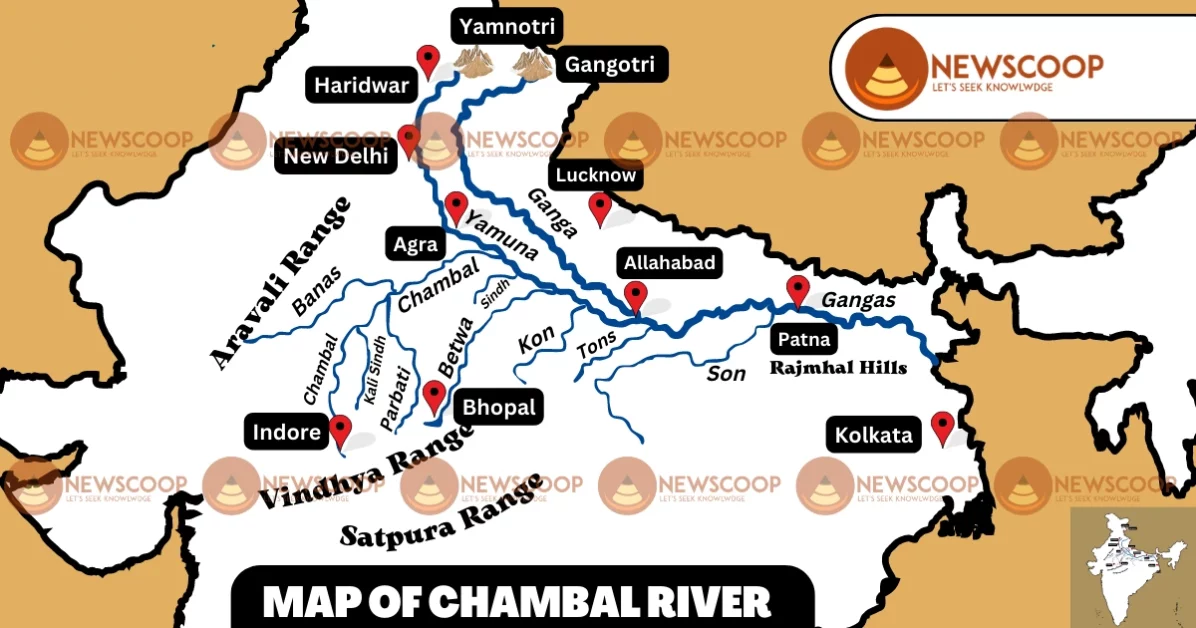
- The Chambal River and its tributaries drain the Malwa region of northern Madhya Pradesh, while the Banas, which is a tributary of the Chambal, rises in the Aravalli Range and drains southeastern Rajasthan.
- The Chambal River’s most significant landmark is located at Pachnada near Bhareh in Uttar Pradesh, where it comes to a head at a confluence of five rivers: the Chambal, Kwari, Yamuna, Sind, and Pahuj. This confluence holds immense religious and cultural importance for the local people.
- The Chambal River is fed by several tributaries, including the Banas and Mej Rivers on the left bank, and the Parbati, Kali Sindh, and Shipra Rivers on the right bank.
Origin and Source of Chambal River
The Chambal River originates in the Singar Chouri peak of the Vindhya Range, near Mhow in the Indore district of Madhya Pradesh, India. The Singar Chouri Peak is located at an elevation of approximately 824 meters. From this point, the river flows in a northeasterly direction through Madhya Pradesh, Rajasthan, and Uttar Pradesh, ultimately joining the Yamuna River near Etawah in Uttar Pradesh.
Map of Chambal River
Drainage Basin of River Chambal
The Chambal River is the most prominent river of the Malwa flat terrain, and its basin includes ditches, floodplains, and gorges. In Rajasthan, the Hadauti terrain emerges in the upper drainage basin of the Chambal River, southeast of the Mewar Valley. The river basin emerges in the Malwa terrain to the east and can be geographically categorized into the Deccan Lava (Malwa) terrain and the Vindhyan escarpment area.
According to Heron’s findings in 1953, the pediplain in the east, located between the Vindhyan terrain and the Aravalli mountain range, has a narrow thin layer of quaternary deposits, altered topsoil, and river canal materials. Additionally, two worn-down layers from the Tertiary period can be identified in the pediplain region. The Vindhyan plateau, the neighboring Chambal basin, and the Indo-Gangetic alluvial territory (older alluvium) date back to the Pleistocene to the Sub-recent period.
The Chambal basin is characterized by badland landscapes, while kankar has developed extensively in the older alluvial deposit.
Dams on the Chambal River
Following are the Dams on the Chambal River:
- Gandhi Sagar Dam
- Rana Pratap Sagar Dam
- Jawahar Sagar Dam
- Kota Barrage
1. Gandhi Sagar Dam
- Located in Mandsaur district of Madhya Pradesh, India, it is one of the largest dams built on the Chambal River.
- Constructed in 1960, it has a height of 64 meters and a length of 575 meters.
- It has a total capacity of 7.3 billion cubic meters of water and provides water for irrigation and power generation.
- It also supports a hydroelectric power station with an installed capacity of 115 MW.
- The dam has helped in controlling floods in the downstream areas of the Chambal River.
- The Gandhi Sagar Sanctuary, situated adjacent to the dam, is a popular tourist attraction and is home to several species of wildlife.
2. Rana Pratap Sagar Dam
- Located in the Chittorgarh district of Rajasthan, it is another significant dam built on the Chambal River.
- Constructed in 1970, it has a height of 54 meters and a length of 1,167 meters.
- It has a total capacity of 1.17 billion cubic meters of water and provides water for irrigation and power generation.
- It supports a hydroelectric power station with an installed capacity of 172 MW.
- The dam is named after the famous Rajput warrior, Rana Pratap Singh.
3. Jawahar Sagar Dam
- Located in the Kota district of Rajasthan, it is a hydroelectric dam built on the Chambal River.
- Constructed in 1972, it has a height of 45 meters and a length of 393 meters.
- It has a total capacity of 1.02 billion cubic meters of water and generates electricity.
- It supports a hydroelectric power station with an installed capacity of 99 MW.
- The dam also provides water for irrigation.
- It is named after Jawaharlal Nehru, the first Prime Minister of India.
4. Kota Barrage
- Located in the Kota district of Rajasthan, it is a multipurpose dam built on the Chambal River.
- Constructed in 1960, it has a length of 890 meters and a height of 24 meters.
- It has a total capacity of 12.9 billion cubic meters of water and provides water for irrigation, flood control, and navigation.
- The barrage supports a hydroelectric power station with an installed capacity of 172 MW.
- It has 24 gates to regulate the flow of water in the river.
- The Kota Barrage is an important landmark and tourist attraction in the city of Kota.
Tributaries of Chambal River
Following are the tributaries of the Chambal River:
- Banas River
- Mej River
- Parbati River
- Kali Sindh River
- Shipra River
| Left Bank Tributaries | Origin | Joining Point |
|---|---|---|
| Banas River | Khamnor hills in the Aravalli Range | Near Rameshwar in Rajasthan |
| Mej River | Mewar region of Rajasthan | Kota Barrage |
| Right Bank Tributaries | Origin | Joining Point |
|---|---|---|
| Parbati River | Malwa region of Madhya Pradesh | Kota Barrage |
| Kali Sindh River | Vindhya Range | Near Bhind in Madhya Pradesh |
| Shipra River | Vindhya Range | Near Ghinoda in Rajasthan |
Left Bank Tributaries
- Banas River: It originates from the Khamnor hills in the Aravalli Range and joins the Chambal near the village of Rameshwar in Rajasthan. It is the largest left-bank tributary of the Chambal.
- Mej River: It originates in the Mewar region of Rajasthan and joins the Chambal near the Kota Barrage.
Right Bank Tributaries
- Parbati River: It originates in the Malwa region of Madhya Pradesh and flows through the districts of Mandsaur and Jhalawar in Rajasthan before joining the Chambal near the Kota Barrage.
- Kali Sindh River: It originates in the Vindhya Range and flows through the districts of Shivpuri and Guna in Madhya Pradesh before joining the Chambal near Bhind in Madhya Pradesh.
- Shipra River: It originates in the Vindhya Range and flows through the districts of Indore and Ujjain in Madhya Pradesh before joining the Chambal near the village of Ghinoda in Rajasthan.
Historical Significance of Chambal River
The Chambal River holds significant historical significance. In the ancient Hindu scriptures, the river is known as Charmanyavati. In the epic Mahabharata, the river formed the southern boundary of Panchala state, with King Drupada ruling the southern states of Panchalas along its banks, while the northern region was a part of the kingdom of Shakuni.
As per popular belief, after the disrobing incident of Draupadi, she cursed anyone who drinks the waters of the river will perish. While the reason for the absence of major settlements along the river banks, except for Kota, may not be entirely attributed to this myth, it has contributed to the folklore and legends associated with the river.
Overall, the Chambal River’s mentions in ancient scriptures and epics attest to its crucial role in shaping the history and culture of the region. Its significance extends beyond just being a geographical landmark, as it has become a part of the folklore and legends of the region.
Flora & Fauna in Chambal River
The Chambal River is renowned for its unique and diverse ecosystem. Here are some flora and fauna found in the Chambal River:
Flora:
- The river is surrounded by the riverine forest, which is dominated by trees such as Babul, Khair, Dhak, and Ber.
- Other trees found in the area include Neem, Pipal, Banyan, and Jamun.
- The riverbank vegetation includes grasses, shrubs, and herbs.
Fauna:
- The Chambal River is known for its population of critically endangered Ganges River Dolphins, also called the South Asian River Dolphins.
- The river also has a high population of the endangered Indian Skimmer, which is a bird that feeds on small fish in the river.
- Other bird species found in the Chambal River include the Indian Courser, Great Thick-knee, and Small Pratincole.
- The river is also home to various species of turtles, including the endangered Three-striped Roof Turtle, Indian Softshell Turtle, and Indian Flapshell Turtle.
- Fish species found in the Chambal River include the Mahseer, Goonch, and Catfish.
Economic Importance
The Chambal River has significant economic importance for the region it flows through. Here are some points regarding its economic significance:
- Irrigation: The river provides water for irrigation purposes to the surrounding agricultural lands. The construction of dams and barrages on the river has helped in providing a regulated supply of water to the farms, enabling farmers to grow multiple crops.
- Fisheries: The river is home to a variety of fish species, making it an important source of fish for the local communities. The Chambal River has a significant presence of Mahseer fish, which is considered a game fish and attracts tourists.
- Tourism: The scenic beauty and biodiversity of the Chambal River attract a large number of tourists every year. The National Chambal Sanctuary, which is spread over three states, provides a natural habitat for the critically endangered Ganges River Dolphin, as well as for many species of birds, reptiles, and mammals.
- Transportation: The Chambal River has historically been used for transportation purposes, although its usage has declined with the construction of roadways and railways. However, the river still serves as an important mode of transportation for goods and people in certain areas.
- Power Generation: The construction of dams and barrages on the Chambal River has enabled the generation of hydroelectric power. The Gandhi Sagar Dam, Rana Pratap Sagar Dam, and Jawahar Sagar Dam are some of the major hydroelectric power stations on the river.
Overall, the Chambal River’s economic significance is tied to its role in providing water for agriculture, fisheries, tourism, transportation, and power generation.
National Chambal Sanctuary
The National Chambal Sanctuary is a protected area located on the Chambal River in northern India. The sanctuary spans across three Indian states: Rajasthan, Madhya Pradesh, and Uttar Pradesh. It was established in 1979 and covers an area of 5400 square kilometers.
The sanctuary is home to a diverse range of flora and fauna. It is particularly known for its population of critically endangered Gharial, a species of crocodile found only in the Indian subcontinent. The Chambal River is one of the few remaining strongholds of this species, and the sanctuary has played a crucial role in their conservation.
Apart from Gharials, the sanctuary is also home to other species of crocodiles, turtles, and a wide variety of fish. It is also a birdwatcher’s paradise, with over 300 species of birds recorded in the area, including the endangered Indian Skimmer.
The National Chambal Sanctuary is not only a vital ecological hotspot but also holds significant cultural and historical importance. The river has been mentioned in various Hindu scriptures, and the sanctuary is home to several ancient temples and ruins. The sanctuary also supports the livelihoods of local communities, which rely on fishing, agriculture, and tourism.
To promote tourism, the sanctuary offers various activities like river safaris, nature walks, and birdwatching tours. It also supports sustainable livelihoods by providing training and employment opportunities to local communities in ecotourism and other related fields.
Conclusion
In conclusion, the Chambal River holds great significance in the history, culture, and economy of northern India. The river and its surrounding areas provide a rich habitat for a diverse range of flora and fauna, making it an important ecological resource. The construction of dams and other projects on the river has brought about both positive and negative impacts on the region’s economy and ecosystem.
The National Chambal Sanctuary, established to protect the river and its wildlife, serves as a testament to the importance of preserving the river’s natural resources. Despite facing threats such as pollution and overuse, the Chambal River remains an important lifeline for the people and wildlife that depend on it. It is important for us to continue to study and protect this vital resource for future generations.
Thank You!
What are the states through which the Chambal River flows?
The Chambal River flows through the states of Madhya Pradesh, Rajasthan, and Uttar Pradesh.
What is the length of the Chambal River?
The Chambal River is approximately 1024 kilometers long and runs through three Indian states: Madhya Pradesh, Rajasthan, and Uttar Pradesh.
What are the main tributaries of the Chambal River?
The main tributaries of the Chambal River are the Banas and Mej rivers on the left bank, and the Parbati, Kali Sindh, and Shipra rivers on the right bank.
Related Links: