
The Baitarani River, located in Odisha, is a captivating waterway that holds immense historical, cultural, and ecological significance. For UPSC (Union Public Service Commission) aspirants seeking a deeper understanding of Odisha’s heritage, exploring the Baitarani River can provide valuable insights.
In this article, we will cover its physical feature, rich history, ecological importance, and socio-cultural significance, shedding light on why it deserves attention from UPSC aspirants.
| Aspect | Baitarani River |
|---|---|
| Origin | Gonasika hills, Keonjhar district, Odisha |
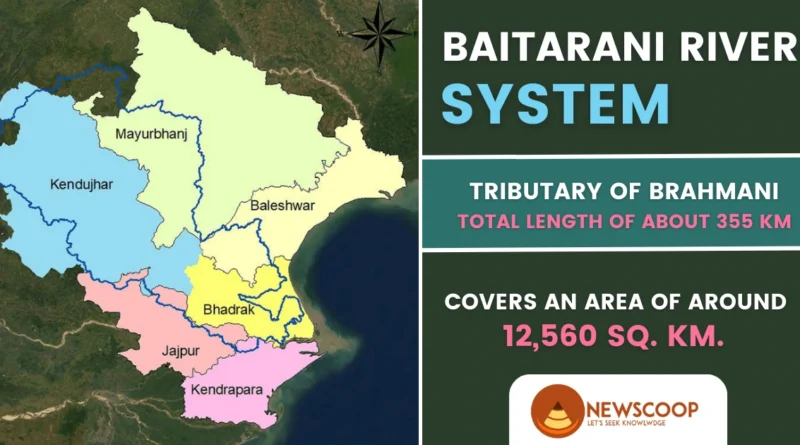
| Total Length | Approximately 355 kilometers |
| Flow Direction | Northeast |
| Tributaries | 65 tributaries (35 from left, 30 from right) |
| Irrigation Potential | 61,920 hectares |
Physical Features of Baitarani River
The Baitarani River is a significant waterway located in the state of Odisha, India. It stretches across a length of approximately 360 kilometers, originating from the Gonasika hills of the Keonjhar district and flowing through the Jajpur and Bhadrak districts before finally merging with the Bay of Bengal. Let’s explore the physical features that define the Baitarani River:
- Origin: Gonasika Hills in Keonjhar district, Odisha, India.
- Length: Approximately 355 kilometers.
- Flow: Northeast direction, passing through Keonjhar, Jajpur, and Bhadrak districts.
- Tributaries: 65 tributaries, with 35 joining from the left side and 30 joining from the right side.
- Surroundings: Surrounded by the Brahmani basin on the South and West, the Subarnarekha basin on the North, and the Burhabalang and the Bay of Bengal on the East.
- Irrigation Potential: Dams and barrages on the Baitarani and its tributaries irrigate 61,920 hectares (153,000 acres) of land.
- Proposed Projects: Bhimkund and upper Baitarani multi-purpose projects aim to construct more dams for irrigation across the river and its tributaries, potentially covering over 1,000 square kilometers (390 square miles).
- New Barrage: A new barrage has been established near Anandapur to regulate water flow and support irrigation in the surrounding areas.
Origin and Source of Baitarani River
The Baitarani River originates from the Gonasika hills, situated in the Keonjhar district of Odisha, India. The Gonasika Hills is a picturesque location known for its natural beauty and religious significance. It is believed that the river emerges from the Gonasika Cave, which holds great reverence among Hindu devotees.
The Gonasika Cave is considered to be the source of this River. It is believed to be the abode of Goddess Gonasika, and the river is said to flow out from this cave. The cave itself is adorned with stalactites and stalagmites, adding to its mystique and religious significance.
The Course of Baitarani River
After its origin, the River flows in a northeastern direction, passing through the districts of Keonjhar, Jajpur, and Bhadrak in Odisha. It traverses diverse landscapes, including forests, hills, plains, and wetlands, on its approximately 355-kilometer-long journey.
During the monsoon season, the river experiences heavy rainfall, resulting in increased water levels and a swift current. It provides water for agriculture and sustains local communities along its course. The river eventually merges with the Bay of Bengal near the village of Dhamra in Bhadrak district.
Baitarani River Basin
The Baitarani River forms a part of the Mahanadi River basin, one of the major river systems in eastern India. It covers a basin area of approximately 12,560 square kilometers, encompassing a wide range of ecosystems, including forests, agricultural lands, and wetlands.
The Baitarani River basin is located between East longitudes of 85°10′ to 87°03′ and North latitudes of 20°35′ to 22°15′. It is surrounded by:
- Brahmani basin on the South and West
- Subarnarekha basin on the NorthBurhabalang and the Bay of Bengal on the East.
With a total length of approximately 355 kilometers, the river is known for its flashy nature. The upper reaches of the river extend up to Anandpur in the hilly region, characterized by challenging terrains and picturesque landscapes.
The geographical boundaries and surroundings of the Baitarani River basin contribute to its hydrological dynamics, ecological interactions, and overall significance in the region’s landscape. Understanding these features helps in comprehending the unique characteristics and environmental context of the Baitarani River basin.
Tributaries of Baitarani River
The Baitarani River in Odisha, India, is fed by a total of 65 tributaries, enhancing its flow and hydrological characteristics. Here are some notable tributaries of the Baitarani River:
- Budhi
- Kanjori
- Ambajhara
- Mushal
- Kusei
- Salandi
Historical Significance
- Tracing its roots back to ancient times, the Baitarani River finds mention in various historical texts and scriptures.
- The river has been an important trade route, facilitating the movement of goods and cultural exchanges between Odisha and neighboring regions.
- Its banks are adorned with numerous archaeological sites, including ancient temples, caves, and ruins, offering insights into the region’s rich past.
- The river’s historical significance can be linked to the Mauryan and Kalinga dynasties, the Ashokan edicts, and the glorious maritime history of Odisha.
Ecological Importance & Conservation Efforts
- The River is not only a lifeline for the people of Odisha but also supports a diverse ecosystem, including a variety of flora and fauna.
- The river serves as a vital water source for agricultural activities in the region, ensuring sustenance for local communities.
- However, like many rivers in India, the Baitarani faces challenges such as pollution, siltation, and encroachments, which pose a threat to its ecological balance.
- Conservation initiatives, including river cleaning drives and afforestation projects, are being undertaken to preserve the river’s ecosystem and promote sustainable practices.
Conclusion
The Baitarani River presents a unique opportunity for UPSC aspirants to gain a comprehensive understanding of Odisha’s history, culture, and environment. Its historical significance, ecological importance, and socio-cultural heritage make it a subject worth exploring.
By delving into the multifaceted aspects of the Baitarani, aspirants can enhance their knowledge base, foster a broader perspective, and develop a holistic approach to answering questions in the UPSC examination.
Thank You!
What is the origin of the Baitarani River?
The Baitarani River originates from the Gonasika hills in the Keonjhar district of Odisha, India.
What is the total length of the Baitarani River?
The total length of the Baitarani River is approximately 355 kilometers, flowing through the Keonjhar, Jajpur, and Bhadrak districts of Odisha, India.