The Chenab River, a prominent river in the Indian subcontinent, holds immense significance in the social, economic, and ecological landscape of North India. As an aspirant preparing for the UPSC exam, understanding factual information is crucial.
In this article, we will cover the geographical, historical, hydrological, environmental, and cultural aspects of the Chenab River, providing you with a comprehensive guide to ace the UPSC exam.
Geographical Features of Chenab River
The Chenab River, a significant river in North India, possesses distinct geographical features that contribute to its significance and impact on the surrounding regions. Let’s explore these geographical aspects in detail:
- Originates from the confluence of the Chandra and Bhaga rivers in Himachal Pradesh.
- Approximately 960 kilometers long.
- Covers a drainage basin area of around 141,397 square kilometers.
- Tributaries include Marusudar, Tawi, Ujh, Ravi, Beas, and Parbati rivers.
- Supports hydroelectric power projects including the Salal Dam, Baglihar Dam, Dulhasti Dam, and Kishanganga Hydroelectric Plant.
- Provides water for irrigation.
- Rich in biodiversity, hosting endangered species.
- Holds cultural significance, mentioned in ancient Indian scriptures.
Origin and Course
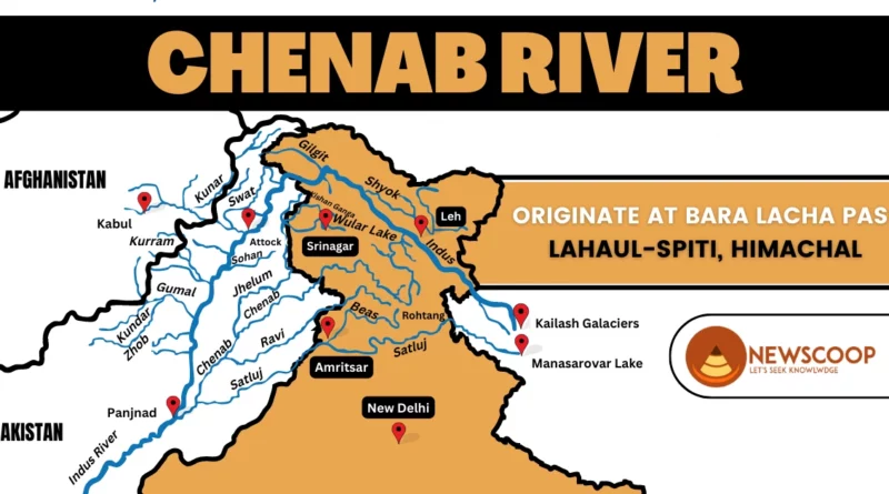
The Chenab River originates from the confluence of two major tributaries, the Chandra and Bhaga rivers, near Bara Lacha Pass in the Lahaul-Spiti district of Himachal Pradesh. Flowing northwest, it passes through Jammu and Kashmir, carving its way through rugged terrains, deep gorges, and narrow passages.
The river then enters the Reasi district, where it showcases its power and beauty with rapids and cascades. As it continues its course, the river enters the plains of Punjab, passing through Gurdaspur and Pathankot districts. Serving as a natural border between India and Pakistan, it finally merges with the Indus River near Trimmu in Pakistan’s Punjab province. Throughout its course, the River offers mesmerizing views of mountains, valleys, and diverse landscapes, leaving an indelible mark on the region’s ecology and shaping its socio-economic fabric.
Drainage Basin of Chenab River
The River boasts an expansive drainage basin, covering a considerable area of approximately 141,397 square kilometers. The basin extends across multiple regions, including the Lahaul and Spiti districts of Himachal Pradesh, the Jammu and Kashmir region, and parts of Punjab. The river and its tributaries drain the surrounding catchment area, collecting water from various sources and contributing to the overall flow of the river.
Length and Flow
The total length of the Chenab River is estimated to be around 960 kilometers. Its flow is characterized by a fast and steady pace, owing to the mountainous terrain it passes through. The river’s flow is augmented by the contribution of numerous tributaries, including the Marusudar, Tawi, Ujh, Ravi, Beas, and Parbati Rivers.
Map of Chenab River

Tributaries of the Chenab River
The following are the tributaries of the Chenab River:
- Marusudar River
- Tawi River
- Ujh River
- Ravi River
- Beas River
- Parbati River
- Jhelum River
Dams on the Chenab River
Here is a list of some notable dams constructed on the Chenab River:
- Salal Dam
- Baglihar Dam
- Dulhasti Dam
- Pakal Dul Dam
- Ratle Dam
Historical Significance
The Chenab River holds great historical significance, as it has witnessed the rise and fall of several civilizations over the centuries. It has been mentioned in ancient Indian scriptures, including the Rigveda and the Mahabharata, where it was known as the “Chandrabhaga River.” The river’s banks have been witness to the reigns of various dynasties, such as the Mauryas, Kushans, and Mughals, who recognized its strategic importance for trade and defense.
Biodiversity & Ecological Importance
The Chenab River basin hosts a rich biodiversity, supporting a variety of flora and fauna. The river serves as a habitat for numerous species, including the critically endangered Indus River dolphin (Platanista Gangetica minor) and the vulnerable snow leopard (Panthera uncia). The surrounding wetlands and marshes provide crucial breeding grounds for migratory birds, making it a significant site for birdwatching enthusiasts.
Conclusion
The Chenab River, with its historical, cultural, and ecological significance, stands as a lifeline of North India. Its flowing waters have shaped the lives of communities, provided opportunities for economic growth, and supported diverse ecosystems.
However, the challenges it faces in terms of pollution and degradation demand immediate attention and sustainable conservation efforts. By recognizing the value of this majestic river, we can work towards preserving it for future generations.
Thank You!
What is the origin of the Chenab River?
The Chenab River originates from the confluence of the Chandra and Bhaga rivers near Bara Lacha Pass in the Lahaul-Spiti district of Himachal Pradesh, India.
What is the total length of the Chenab River?
The Chenab River has a length of approximately 960 kilometers, making it one of the significant rivers in the Indian subcontinent.