
The Indus River System is a network of rivers, streams, and canals located in South Asia, primarily in Pakistan and India. It is one of the largest river systems in the world, covering an area of approximately 1.1 million square kilometers. The system is formed by the Indus River and its tributaries, including the Jhelum, Chenab, Ravi, Beas, and Sutlej Rivers.
The Indus River System is an important source of water for millions of people who live in the region. It has played a significant role in the development of human civilization in the region for thousands of years and continues to be a critical resource for agriculture, industry, and other sectors.
| River | Indus River |
| Location | South Asia |
| Countries | Pakistan, India |
| River Basin Area | 1,165,000 sq. km |
| Area in India | 321,289 sq. km |
| Total Length | 2,880 km |
| Length in India | 1,114 km |
| Major Tributaries | Jhelum, Chenab, Ravi, Beas, Sutlej |
| Origin | Bokhar Glacier in Tibetan |
| Altitude at Origin | 4,164 meters |
| Name in Tibet | Singi Khamban (Lion’s mouth) |
| Deepest Gorge | Gilgit-Baltistan, approximately 5200 meters |
| Outflow | Bokhar Glacier, a Tibetan region |
The Indus River System
There are some important points on the Indus River System for UPSC Examination:
- The Indus River System is located in South Asia, running through Pakistan and India.
- Also known as Sindhu River.
- The Indus River System is one of the largest river basins globally, covering an area of 1,165,000 sq. km.
- In India, it covers an area of 321,289 square kilometers, with a total length of 2,880 kilometers, out of which 1,114 kilometers are in India.
- The system also includes several major tributaries, such as the Jhelum, Chenab, Ravi, Beas, and Sutlej rivers, which flow through India and into Pakistan.
- The Indus River is the westernmost flowing river of the Indian subcontinent and is also known as the Sindhu.
- It originates from the Bokhar glacier in the Tibetan region, near Manasarovar, at an altitude of 4,164 meters in the Kailash Mountain range. In Tibet, it is known as ‘Singi Khamban‘ or Lion’s mouth.
- The river flows through Ladakh in a northwest direction between the Ladakh and Zaskar ranges towards the Gilgit-Baltistan region. It cuts across the Ladakh range, forming a spectacular gorge near Gilgit in Jammu and Kashmir.
- The Indus River is joined by the Zaskar River at Leh and flows in a southerly direction along the entire length of Pakistan before merging into the Arabian Sea near the port city of Karachi in Sindh.
- The deepest gorge formed by the Indus River is located in Gilgit-Baltistan and is around 5200 meters deep.
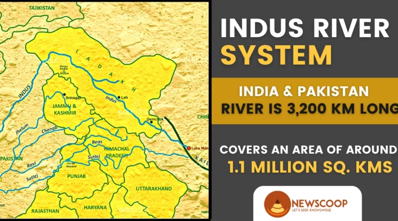
Map of the Indus River System
The following map provides a visual representation of the Indus River system, a major river network in South Asia. It includes the Indus River and its significant tributaries, such as the Jhelum, Chenab, Ravi, and Sutlej. Originating in Tibet, it flows through India and predominantly through Pakistan, playing a pivotal role in regional agriculture and commerce.

Historical Significance of the Indus River
The Indus River has significant historical and cultural importance in the Indian subcontinent. Here are some key points:
- The Indus Valley Civilization: The Indus River was the cradle of the Indus Valley Civilization, one of the oldest and most advanced civilizations in the ancient world. The civilization flourished in the Indus River basin from around 2600 BCE to 1900 BCE, and its ruins can be found in present-day India and Pakistan.
- Religious Significance: The Indus River is considered sacred by Hindus, who believe that a dip in the river can cleanse one’s sins. The river is also mentioned in ancient Indian texts such as the Rigveda and the Mahabharata.
- Trade and Commerce: The Indus River has been an important trade route for centuries, connecting the Indian subcontinent to Central Asia and the Middle East. The river facilitated the movement of goods such as textiles, spices, and precious stones.
- Alexander the Great: The Indus River played a significant role in the conquests of Alexander the Great in the 4th century BCE. Alexander and his army crossed the river at the Battle of the Hydaspes, which took place near present-day Jhelum in Pakistan.
- Modern-Day Importance: Today, the Indus River and its tributaries are a lifeline for millions of people in India and Pakistan, providing water for agriculture, industry, and domestic use. The Indus Water Treaty, signed in 1960, governs the use of the river’s water by India and Pakistan.
Tributaries of the Indus River
The Indus River System is comprised of the Indus River and its many tributaries. Following are the left and right bank tributaries of the Indus River:
Left Bank Tributaries
- Jhelum River
- Chenab River
- Ravi River
- Beas River
- Sutlej River
- Zaskar river
- Suru river
- Soan river
Right Bank Tributaries
- Shyok River
- Gilgit River
- Hunza River
- Swat River
- Kunar River
- Kurram River
- Kabul River
| Tributary Name | Location (Left/Right Bank) | Length (km) | Joins Indus River At |
|---|---|---|---|
| Jhelum River | Left | 725 | Mangla Dam in Pakistan |
| Chenab River | Left | 1,180 | Uch Sharif in Pakistan |
| Ravi River | Left | 720 | Shahdara near Lahore, Pakistan |
| Beas River | Left | 470 | Harike Wetland in India |
| Sutlej River | Left | 1,550 | Mithankot in Pakistan |
| Gilgit River | Right | 174 | Gilgit in Pakistan |
| Shigar River | Right | 116 | Shigar in Pakistan |
| Hunza River | Right | 190 | Gilgit River in Pakistan |
| Astore River | Right | 120 | Gilgit River in Pakistan |
| Swat River | Right | 219 | Kabul River in Pakistan |
| Kabul River | Right | 700 | Attock in Pakistan |
Major Left Bank Tributaries
1. Jhelum River
- The Jhelum River is a left-bank tributary of the Indus River.
- It originates from Sheshang Lake near Verinag Spring in the southeastern part of the Kashmir Valley.
- The Lidder River and Sind River are two of its major tributaries, which join the Jhelum River in the Kashmir Valley.
- It flows through Srinagar and Wular Lake before entering Pakistan through a deep, narrow gorge.
- The Jhelum River meanders during its youth stage due to lacustrine deposits called Karewas in an ancient lake bed, which creates plains-like topography.
2. Chenab River
- The Chenab River originates from the Bara Lacha Pass in the Lahul-Spiti part of the Zaskar Range.
- It flows through the Indian states of Himachal Pradesh and Jammu and Kashmir before meeting the Jhelum River in Pakistan.
- The river is formed by the confluence of two streams, Chandra and Bhaga, in the western Himalayas in India’s Himachal Pradesh state at Keylong.
- The united stream Chandrabhaga flows in the northwest direction through the Pangi valley, parallel to the Pir Panjal range.
- The Chenab River cuts a deep gorge near Kistwar in Jammu and Kashmir.
- It is the largest tributary of the Indus River.
3. Ravi River
- The Ravi River originates from the Kullu hills near the Rohtang Pass in Himachal Pradesh.
- It flows through the area between the Pir Panjal and Dhaola Dhar ranges.
- After crossing Chamba, the river takes a south-westerly turn and cuts a deep gorge in the Dhaola Dhar range.
- The Ravi River eventually meets the Chenab River, which flows into the Arabian Sea.
4. Beas River
- The Beas River originates near the Rohtang Pass, at an altitude of 4,062 m above sea level, on the southern end of the Pir Panjal Range, close to the source of the Ravi.
- It flows through the Dhaola Dhar range and takes a south-westerly direction.
- The Beas River meets the Satluj River at Harike in Punjab, after covering a distance of around 460 km.
- Although the Beas River is relatively small, it lies entirely within the Indian territory.
- The Beas River is an important source of irrigation water in Punjab and is used extensively for agricultural purposes.
5. Satluj River
- The Satluj River originates from the Manasarovar-Rakas Lakes in western Tibet, close to the source of the Indus.
- It flows in a northwesterly direction up to the Shipki La on the Tibet-Himachal Pradesh boundary.
- The river cuts deep gorges where it pierces the Great Himalayas and other Himalayan ranges.
- The Satluj River passes through the Naina Devi Dhar gorge before entering the Punjab Plain.
- The Bhakra-Nangal dam, a famous hydroelectric power project, has been constructed in the Naina Devi Dhar gorge on the Satluj River.

Dams on the Indus River System
The following table shows the Dams on the Indus River System:
| Dam Name | River | Location |
|---|---|---|
| Bhakra Dam | Satluj | Bilaspur, Himachal Pradesh |
| Nangal Dam | Satluj | Rupnagar, Punjab |
| Pong Dam | Beas | Kangra, Himachal Pradesh |
| Thein Dam | Ravi | Pathankot, Punjab |
| Baglihar Dam | Chenab | Doda, Jammu & Kashmir |
| Salal Dam | Chenab | Baramulla, Jammu & Kashmir |
| Dul Hasti Dam | Chenab | Kishtwar, Jammu & Kashmir |
| Uri-I Dam | Jhelum | Baramulla, Jammu & Kashmir |
| Uri-II Dam | Jhelum | Reasi, Jammu & Kashmir |
| Sewa-II Dam | Chenab | Udhampur, Jammu & Kashmir |
| Chamera-I Dam | Ravi | Chamba, Himachal Pradesh |
| Chamera-II Dam | Ravi | Chamba, Himachal Pradesh |
| Chamera-III Dam | Ravi | Chamba, Himachal Pradesh |
| Baghliar Hydroelectric Power Project | Chenab | Baramulla, Jammu & Kashmir |
| Kishanganga Hydroelectric Plant | Kishanganga | Bandipora, Jammu & Kashmir |
Note: This table includes only some of the major dams on the Indus River System in India. There are several other dams and hydroelectric power projects on the Indus River System.
What is the Importance of the Indus River?
The Indus River System holds significant importance for South Asia in terms of agriculture, industry, and energy production. It serves as a major source of water for Pakistan’s agrarian economy, with the majority of its tributaries flowing through Pakistan.
The river system is also crucial for electricity production, with several large dams and hydroelectric power plants located along its course. These dams generate clean energy and help meet the increasing power demand of the region.
Moreover, the Indus River System has played a vital role in shaping the historical and cultural heritage of the region. The ancient Indus Valley Civilization, one of the world’s earliest urban civilizations, flourished along the banks of the Indus River. The river system is also mentioned in several ancient texts and epics, further highlighting its historical and cultural significance.
The Indus Water Treaty signed between India and Pakistan in 1960, is another testament to the importance of the river system in maintaining regional stability and cooperation. The treaty governs the distribution and use of water from the Indus River System between the two countries and has been instrumental in preventing major water disputes between them.
Indus Water Treaty
| Treaty Name | Indus Water Treaty |
|---|---|
| Signed by | Prime Minister Jawaharlal Nehru (India) and President Ayub Khan (Pakistan) |
| Date Signed | September 19, 1960 |
| Brokered by | World Bank (International Bank for Reconstruction and Development) |
| Rivers | Indus, Jhelum, and Chenab for Pakistan; Beas, Ravi, and Satluj for India |
| Water Allocation | 80% to Pakistan; 20% to India (33 million acre-feet from three rivers) |
| Utilization | The treaty sets out a mechanism for cooperation and information exchange between the two countries regarding their use of the rivers |
| Commission | Permanent Indus Commission (bilateral commission to implement and manage the treaty) |
| Meetings | Water commissioners of Pakistan and India meet twice a year |
| Cooperation | Treaty sets out mechanism for cooperation and information exchange between the two countries regarding their use of the rivers |
Key Points:
- The Indus River Treaty is a water-sharing agreement signed between India and Pakistan in 1960.
- The treaty was brokered by the World Bank to resolve disputes between the two countries over the sharing of water from the Indus River system.
- The Indus River system includes the Indus River and its five main tributaries: Jhelum, Chenab, Ravi, Beas, and Sutlej.
- Under the treaty, India was given control over the waters of the three eastern rivers – Ravi, Beas, and Sutlej, while Pakistan was given control over the waters of the two western rivers – Jhelum, and Chenab.
- Both countries were allowed unrestricted use of the waters of their respective rivers for agricultural, domestic, and non-consumptive purposes.
- Non-consumptive use includes activities like irrigation, fishing, storage, and electricity production.
- India was allowed to generate hydroelectric power on the western rivers, subject to specific limitations on the design and operation of the dams.
- However, India has not fully utilized this provision yet.
- The treaty allocates 80% of the water from the six-river Indus water system to Pakistan, which includes the western rivers as well as the eastern rivers of Beas, Ravi, and Sutlej.
- The treaty established a permanent Indus Commission consisting of a commissioner from each country to facilitate communication and cooperation between India and Pakistan in implementing the treaty.
- The treaty also included provisions for the exchange of data and information on the flow of water in the rivers and the construction of new water projects.
- As per the Indus Water Treaty signed between India and Pakistan, the water commissioners of both countries are required to meet twice a year and arrange technical visits to project sites and critical river head works
- The treaty has been in force for over 60 years and has survived several conflicts between India and Pakistan.
Indus River Dolphin
The Indus River Dolphin (Platanista gangetica minor) is a highly important and endangered species found exclusively in the Indus River system of Pakistan. Here are some key points about the Indus River Dolphin:
- Unique physical characteristics: Long and narrow snout, stocky body, small eyes, and low triangular dorsal fin.
- Habitat and distribution: Found in the main stem of the Indus River and its tributaries, adapted to freshwater and deep pools.
- Echolocation: Relies on echolocation to navigate and locate prey in murky waters using high-frequency clicks.
- Feeding habits: Primarily feeds on various fish species in the Indus River system using its long snout and sharp teeth.
- Population decline and conservation efforts: Drastic decline due to dam construction, pollution, and illegal fishing. Conservation initiatives include protected areas and awareness campaigns.
- Cultural significance: Symbolic and culturally significant, known as the “blind dolphin” or “Bhulan,” representing the Indus River ecosystem.
The conservation status of the Indus River Dolphin (Platanista gangetica minor):
- IUCN Red List: Endangered
- CITES: Appendix I
- Wildlife (Protection) Act, 1972: Schedule I
Read in Detail: Indus River Dolphin
Environmental Concerns and Challenges
The Indus River system faces several environmental concerns and challenges, which include:
- Climate Change: The melting of glaciers due to rising temperatures and erratic weather patterns is affecting the flow of the Indus River, and altering the natural water cycle of the region.
- Water Scarcity: The Indus River basin is one of the most water-stressed regions in the world, and the demand for water is increasing rapidly due to population growth, urbanization, and agricultural expansion.
- Water Pollution: Industrial, agricultural, and domestic activities contribute to water pollution, which impacts the health of aquatic life and human populations dependent on the river for drinking and irrigation.
- Deforestation and Land Degradation: The destruction of forests and soil erosion have led to a decline in soil fertility and the loss of important ecosystems, affecting the overall health of the river system.
- Overfishing: Overfishing is a growing concern, as it can lead to a decline in fish populations and disrupt the aquatic food chain, ultimately impacting the livelihoods of local fishing communities.
Future Prospects
The future prospects of the Indus River system are largely dependent on effective management and cooperation between India and Pakistan. Climate change and the growing population in the region pose significant challenges to the availability and distribution of water resources. Therefore, sustainable and innovative practices are required to ensure the continued availability of water resources for agriculture, industry, and domestic use.
There is also a potential for the development of hydroelectric power projects on the river system, which could provide clean energy and support economic growth. However, any such projects would need to be implemented with careful consideration of their environmental impact and the rights of downstream communities.
Conclusion
In conclusion, the Indus River System holds immense significance for the economy, environment, and people of Pakistan and India. While the Indus Water Treaty has been successful in managing the water resources of the region, the system is facing several challenges, including climate change, water scarcity, and environmental degradation.
However, with proper management and cooperation, the Indus River System can continue to provide economic and social benefits to the region. It is important for both countries to work together and take necessary measures to preserve and sustainably use this vital resource.
Thank You!
What is the total length of the Indus River?
The total length of the Indus River is approximately 2,880 kilometers. It flows through Pakistan and India, forming one of the largest river basins in the world.
Where does the Indus River originate?
The Indus River originates from the Bokhar glacier in the Tibetan region, near Manasarovar, at an altitude of 4,164 meters in the Kailash Mountain range.
What are the major tributaries of the Indus River?
The major tributaries of the Indus River are the Jhelum, Chenab, Ravi, Beas, and Sutlej Rivers, which flow through India and eventually merge into the Indus River in Pakistan.
What are the five rivers of Punjab?
The five rivers of Punjab are the Beas River, Chenab River, Jhelum River, Ravi River, and Sutlej River.
Related Links: