
The Ken River, flowing through the heart of central India, is a remarkable waterway that holds immense ecological significance and cultural heritage. Originating from the village Ahirgawan in Madhya Pradesh, this majestic river meanders through rugged terrains, enriching the states of Madhya Pradesh and Uttar Pradesh with its pristine waters and breathtaking landscapes.
Aspiring civil servants preparing for the UPSC exam must acquaint themselves with the significance of the Ken River, as it encompasses diverse aspects ranging from biodiversity conservation to historical importance.
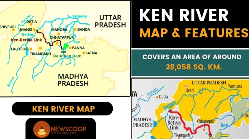
Geographical Features of Ken River
Following are the geographical features of the Ken River:
- The Ken River is located between 23°20′ and 25°20′ north latitude and 78°30′ and 80°32′ east longitude.
- The Ken River begins near Ahirgawan Village in Jabalpur District, M.P., at an elevation of 550 meters above sea level.
- The Ken River joins the Yamuna River near Chilla Village in Uttar Pradesh, at an elevation of around 95 meters.
- It is the state boundary between M.P.’s Panna and Chhattarpur districts, as well as the common boundary between M.P.’s Chhattarpur and Banda districts (U.P.).
- The river is 427 kilometers long:
- 292 kilometers in M.P.
- 84 kilometers in U.P.
- 51 kilometers as the common boundary.
- The River basin has a total catchment area of 28,058 square kilometers, with 24,472 square kilometers in Madhya Pradesh and 3,586 square kilometers in Uttar Pradesh.
- Important tributaries include Sonar, Bearma, Kopra, Bewas, Urmil, Mirhasan, Kutni, Kail, Gurne, Patan, Siameri, Chandrawal, Banne, and others.
- Sonar is the longest tributary, spanning 227 kilometers within M.P., and has a catchment area of 12,620 square kilometers.
- The Sonar sub-basin is entirely within Madhya Pradesh, with a catchment area of 6,550 square kilometers. It is bordered by the Bearma Basin to the east, the Dhasan Basin to the west, and the Vindhyan Ranges to the south.
- Major districts in the Sonar sub-basin include Sagar, Damoh, and portions of Panna, Chattarpur, and Raisen.
- Other significant tributaries of the Ken River include Bewas, Dehar, Kaith, Baink, Kopra, and Bearman.
Tributaries of Ken River
The Ken River is fed by several important tributaries. Here are some of the notable tributaries of the Ken River:
- Sonar
- Bearma
- Kopra
- Bewas
- Urmil
- Mirhasan
- Kutni
- Patan
- Chandrawal
- Dehar
- Baink
Topography of the Ken River Basin
The geological and topographical features surrounding the Ken River basin are described as follows:
Upper Reaches: The upper reaches of the Ken River are characterized by an undulating plateau consisting of sandstone, shale, and limestone formations. These rock formations contribute to the overall landscape and geological composition of the region.
Alluvial Deposits: As the river flows downstream, the lower areas are covered by recent alluvium deposits, which are fine-grained sediments carried and deposited by the river. These alluvial soils contribute to the fertility of the land in the surrounding areas.
Rock Formations: The region surrounding the Ken River exhibits a diverse range of rock formations. This includes alluvial soil, Deccan traps (a volcanic rock formation), Lameta beds (a sedimentary rock formation), and the Vindhyan system (a prominent rock formation in central India). These rock formations contribute to the geological diversity of the region.
Betwa Basin: The Betwa basin, which is adjacent to the Ken River basin, covers areas of Bundelkhand uplands, Malwa plateau, and Vindhyan scarp lands. These areas have their own distinct topographical features and geological characteristics.
Left Bank and Right Bank: The left bank of the project site gradually rises for a distance of about 350 meters before experiencing a slightly steeper rise beyond an elevation of 287 meters. On the other hand, the right bank is relatively flat for about 350 meters and then becomes steeper, continuing up to the top of the hill. This variation in bank profiles influences the layout and positioning of structures such as the spillway and powerhouses.
Reservoir Area: The reservoir area of the Ken River lies primarily in the Panna and Chhatarpur districts of Madhya Pradesh. The region is characterized by the presence of Bundelkhand granite, overlaid by the Bijawar group, and further overlaid by the Vindhyan Supergroup. The surrounding hills have elevations exceeding 400 meters, creating a picturesque and elevated landscape around the reservoir.
These geological and topographical features contribute to the overall character and environment of the Ken River basin, influencing the landforms, soil composition, and natural resources found in the region.
Conclusion
In summary, the Ken River is an important interstate river in India, flowing through Madhya Pradesh and Uttar Pradesh. It originates in Jabalpur district and joins the Yamuna River in Uttar Pradesh. The river basin covers 28,058 square kilometers, with diverse geological features such as plateaus, alluvial deposits, and rock formations.
The basin is home to various tributaries. The Ken River plays a crucial role in irrigation, water supply, and hydroelectric power generation. Conservation efforts are necessary to protect this vital resource and maintain the ecological balance in the region.
Thank You!