
The Kosi River, also known as the “Sorrow of Bihar,” is a significant river that flows through the northern part of India and Nepal. It originates from the high Himalayas and traverses through the states of Bihar and Uttar Pradesh before joining the Ganges River. The river has a rich historical and geographical significance, making it an important topic for the UPSC examination.
In this article, we will delve into the various aspects of the Kosi River, including its origin, course, historical significance, environmental challenges, and the measures taken for its management.
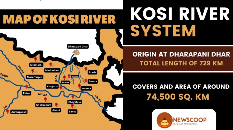
Kosi River of Bihar
The Kosi River catchment encompasses six geological and climatic belts, ranging in altitude from above 8,000 m (26,000 ft) to 95 m (312 ft). These belts include the Tibetan plateau, the Himalayas, the Himalayan mid-hill belt, the Mahabharat Range, the Siwalik Hills, and the Terai.
Further, the Kosi River basin shares borders with the Tsangpo River basin in the north, the Mahananda River basin in the east, the Ganges Basin in the south, and the Gandaki River basin in the west. The basin is fed by several tributaries, including the Tamur River, the Arun River, and the Sun Kosi, along with its northern tributaries Dudh Kosi, Likhu Khola, Tama Koshi, Bhote Koshi, and Indravati.
Origin of the Kosi River
The Kosi River has its origin in the majestic Himalayas. It begins its journey from the northern slopes of the Himalayan range in the Tibet Autonomous Region of China. High up in the snow-capped mountains, the river’s early streams and tributaries emerge, gathering strength and volume as they cascade down the steep valleys and gorges. On the southern slopes of the Himalayas, in the beautiful country of Nepal, these tributaries join together to form the mighty Kosi River.
What is the Course of the Kosi River?
Once formed, the Kosi River embarks on a remarkable journey through the landscape of Nepal and India. It flows through the scenic valleys and plains of Nepal, passing through vibrant towns and villages along the way. As it crosses the border into India’s state of Bihar, the river meanders through the fertile Gangetic plains, leaving a trail of rich alluvial soil in its wake.
The course of the Kosi River is marked by its meandering nature, constantly changing its path over time. The river’s flow is influenced by seasonal variations, with monsoon rains causing its waters to swell significantly. Due to the large volume of water and the force of its flow, the Kosi River is known for its tendency to change its course and create new channels. This dynamic nature has earned it the nickname “The Sorrow of Bihar” due to the frequent flooding and devastation it can cause.
Eventually, the Kosi River joins the mighty Ganges River near the town of Kursela in Bihar. The confluence of these two rivers signifies the end of the Kosi’s journey, as its waters blend with those of the Ganges, a sacred river in the Indian subcontinent.
Map of Kosi River

Tributaries of Kosi River
Following are the tributaries of the Kosi River:
- Tamur River
- Arun River
- Sun Kosi
- Dudh Kosi
- Likhu Khola
- Tama Koshi
- Bhote Koshi
- Indravati
What are Seven Rivers?
The three major tributaries, Tamur, Arun, and Sun Kosi, meet at Triveni, giving rise to the name Sapta Kosi, meaning Seven Rivers. After passing through the Chatra Gorge, the Sapta Kosi is controlled by the Koshi Barrage before it eventually drains into the Gangetic plain. The river flows through Nepal, passing through Barāhkṣetra and eventually crossing into Bihar, India, near Bhimnagar. After another 260 km (160 mi), it joins the Ganges near Kursela.
Peaks in Kosi River Basin
Prominent Peaks in the Kosi River Basin:
- Mount Everest
- Kangchenjunga
- Lhotse
- Makalu
- Cho Oyu
- Shishapangma
What is Kosi Barrage?
The Kosi Barrage, also known as the Bhimnagar Barrage, is an important infrastructure project on the Kosi River, constructed between 1959 and 1963. It is situated on the Indo-Nepal border and serves multiple purposes, including irrigation, flood control, and hydropower generation. The project was implemented under a bilateral agreement between Nepal and India, with the entire cost being borne by India.
The Kosi River’s catchment area at the barrage site is approximately 61,788 square kilometers (23,856 square miles) in Nepal. The region is characterized by high peaks, and about 10% of the catchment is snow-fed. The Kosi Barrage, along with the Eastern Canal and the Western Canal, was designed to manage water flow and provide irrigation facilities.
The Eastern Canal and Western Canal, originating from the barrage, have discharge capacities:
- Eastern Canal: 455 cubic meters per second (16,100 cubic feet per second)
- Western Canal: 210 cubic meters per second (7,400 cubic feet per second)
The Eastern Canal also houses a hydropower plant with a capacity of generating 20 MW of electricity. This project has contributed to the regional power supply.
The Western Kosi Canal, originating from the barrage, provides irrigation to approximately 250 square kilometers of land in Nepal. This has been instrumental in enhancing agricultural productivity and supporting the livelihoods of local communities.
Additionally, an inundation canal has been constructed at Chatra, where the Kosi River enters the plains. This canal facilitates irrigation across a gross area of 860 square kilometers in Nepal, further bolstering agricultural activities and food production.
Furthermore, the construction of a valuable bridge over the Kosi Barrage has facilitated connectivity and improved transportation infrastructure. This bridge has played a crucial role in opening up the East-West highway in the eastern sector of Nepal, enhancing regional connectivity and trade opportunities.
Sapta Kosi High Multipurpose Project
The governments of India and Nepal are working together on the Sapta Kosi High Multipurpose Project. They are conducting investigations and studies to create a detailed plan for the project. The main goals are to develop hydropower, irrigation, flood control, and navigation.
The project includes the construction of a high dam, a barrage, and two canals. The dam will be built on the Sapta Kosi River and will have an underground powerhouse. It will generate 3,000 MW of electricity, which can power many homes. The barrage will be located about 8 km downstream of the dam to control the diverted water.
Two canals, known as the Eastern Chhatra Canal and Western Chhatra Canal, will be built from the barrage. These canals will provide water for irrigation in both Nepal and India and also support navigation along the Kosi River up to Kursela. The reservoir created by the Sapta Kosi dam will also serve as a water source.
Additionally, a power canal will be constructed from the existing Koshi barrage at Hanuman Nagar. This canal will transport water for irrigation from the Eastern Chatra Canal and provide water downstream for navigation. To make use of the available water pressure between Chatra and Hanuman Nagar, three canal powerhouses are proposed. These powerhouses will generate electricity with an installed capacity of 100 MW each.
The Sapta Kosi High Dam will have the extra storage capacity to help control flooding downstream. This means that during periods of heavy rainfall, the dam can store excess water, reducing the risk of floods.
The Chatra Canal System, a part of this project, will provide irrigation to large areas in Nepal and India, particularly in Bihar. This will help farmers grow crops and support agricultural development.
Overall, the Sapta Kosi High Multipurpose Project aims to bring multiple benefits to both India and Nepal, including clean energy, improved irrigation, flood control, and enhanced navigation along the Kosi River.
Kosi River Floods
The Kosi River is notorious for its annual floods, earning it the nickname “Sorrow of Bihar.” These floods have a significant impact on the region, particularly on the fertile agricultural lands, disrupting the rural economy.
Magnitude of Floods
The Kosi River has an average water flow (discharge) of 2,166 cubic meters per second (76,500 cubic feet/s). However, during floods, this volume can increase up to 18 times the average flow. The greatest recorded flood occurred on 24 August 1954 when the river’s discharge reached 24,200 cubic meters per second (850,000 cubic feet/s). To manage such high floods, the Kosi Barrage has been designed to handle a peak flood of 27,014 cubic meters per second (954,000 cubic feet/s).
Soil Erosion & Sediment Load
The upper catchment area of the Kosi River experiences extensive soil erosion and landslides, resulting in a high silt yield of about 19 cubic meters per hectare per year (10 cubic yards/acre/yr), which is one of the highest in the world. Among the major tributaries, the Arun River contributes the greatest amount of coarse silt in proportion to its total sediment load.
The river transports this sediment downstream through steep gradients and narrow gorges in the mountains and foothills, where the gradient can reach ten meters per kilometer. As the river approaches the Ganges, the gradient reduces to as little as 6 centimeters per kilometer, leading to a decrease in current velocity and the settling of sediment. This deposition occurs on an immense alluvial fan, which covers an area of about 15,000 square kilometers (5,800 square miles).
Lateral Shifting of Channels and Flood Spread
The Kosi River’s alluvial fan extends approximately 180 kilometers (110 miles) from its apex in the foothills, crossing the international border into Bihar state and ultimately reaching the Ganges. The river consists of numerous interlacing channels that shift laterally over the fan over time. Without proper channelization, floods have a wide spread. The record flow of 24,200 cubic meters per second is equivalent to water a meter deep and over 24 kilometers (15 miles) wide, flowing at a rate of one meter per second.
Impacts of Kosi River Floods
- Annual floods of the Kosi River impact around 21,000 sq km of agricultural land, disrupting the rural economy.
- Displacement of communities occurs due to floods, leading to human suffering and loss of homes.
- Infrastructure such as roads, bridges, and buildings suffer damage, affecting transportation and communication networks.
- Crop damage and loss of livestock result in economic losses and increased poverty and food insecurity.
- Public health issues arise from waterborne diseases and inadequate sanitation during floods.
- Education systems are disrupted with damaged schools and children unable to attend classes.
- Migration of affected populations causes social disruption and strains resources in receiving areas.
- Inadequate flood control infrastructure hampers effective flood management efforts.
- Transboundary coordination between Nepal and India is crucial for integrated flood management.
- Climate change adds uncertainty to flood forecasting and management strategies.
Conclusion
In conclusion, the Kosi River is a significant water resource in Nepal and India. It provides water, power, and irrigation to the surrounding regions. However, its annual floods pose challenges and impact the local communities. Efforts have been made to control floods through the Kosi Barrage.
The river also has the potential for hydropower generation, and projects like the Sapta Kosi High Multipurpose Project are being considered. Despite the risks, the river’s resources support agriculture and livelihoods. Sustainable management and collaboration are key to harnessing its benefits while mitigating risks.
Overall, the Kosi River is a dynamic force that shapes the lives and landscapes of the areas it flows through.
Thank You!