
About Periyar River
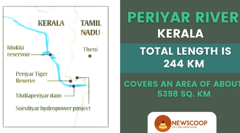
The Periyar River is one of the most significant and ecologically diverse rivers in the state of Kerala, India. It originates from the Western Ghats and flows westward into the Arabian Sea, covering a distance of 244 km. The river basin covers an area of about 5398 sq. km, spanning across the districts of Idukki, Kottayam, and Ernakulam. The Periyar River is known for its unique topography, diverse wildlife, and cultural significance for the local communities.
| River | Periyar River |
| Origin | Western Ghats, Kerala |
| Area cover | 5398 km sq. |
| Total Length | 244 km |
| Altitude | 2383 meters |
| Dams | Mullaperiyar Dam Idukki Dam Lower Periyar Dam Bhoothathankettu Dam |
| Major Tributaries | Muthirapuzha River Cheruthoni River Edamala River Perinjankutti River Pamba River |
Geographical Features & Characteristics of the Periyar River for UPSC
The Periyar River originates from the Sivagiri Peak in the Western Ghats at an altitude of 2,383 meters above sea level. It flows through narrow valleys and cascading waterfalls before joining the Arabian Sea near the city of Kochi.
The river is fed by several tributaries, including Mullayar, Cheruthoni, and Muthirapuzha. The Periyar River is characterized by its steep gradient, fast-flowing water, and rocky terrain, which makes it an ideal spot for adventure tourism and hydroelectric power generation.
Map of Periyar River
The Periyar River flows in a south-westerly direction from its source in the Sivagiri hills, and passes through the following towns and cities before flowing into the Arabian Sea near Kochi:
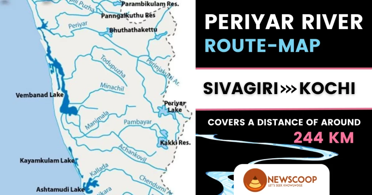
Sivagiri – Peerumedu – Vandiperiyar – Thekkady – Mullaperiyar – Periyar Lake – Periyar Wildlife Sanctuary – Kumily – Vallakadavu – Lower Periyar – Aluva – Eloor – Kochi.
Dams on the Periyar River
The Periyar River in Kerala, India, is home to several dams that serve a variety of purposes, from hydroelectric power generation to irrigation and flood control.
Here are some of the most prominent dams on the Periyar River:
- Mullaperiyar Dam
- Idukki Dam
- Lower Periyar Dam
- Bhoothathankettu Dam
1. Mullaperiyar Dam
- The Mullaperiyar Dam is located in the district of Idukki, Kerala.
- It was built in 1895 by the British government and is operated by the Government of Tamil Nadu.
- The dam is a masonry gravity dam with a maximum height of 176 feet and a capacity of 443,230,000 cubic meters.
- The main purpose of the dam is irrigation, with water being diverted through a tunnel to the Vaigai River in Tamil Nadu.
- The dam also generates up to 13.5 MW of hydroelectric power.
- The dam has been a source of controversy between the governments of Kerala and Tamil Nadu due to safety concerns and the age of the dam.
2. Idukki Dam
- The Idukki Dam is located in the Idukki district of Kerala, India.
- It is a double-curvature arch dam, built across the Periyar River in 1975.
- The dam has a maximum height of 555 feet and is one of the largest arch dams in Asia.
- The main purpose of the dam is hydroelectric power generation, with a capacity of 780 MW.
- The reservoir formed by the dam called the Idukki Reservoir, is spread across an area of 60 square kilometers.
- The Idukki Dam is a popular tourist destination, offering scenic views of the surrounding hills and forests.
3. Lower Periyar Dam
- The Lower Periyar Dam is located in the Idukki district of Kerala, India.
- It is a masonry gravity dam built across the Periyar River in 1957.
- The dam has a height of 41 meters and a length of 242 meters.
- The main purpose of the dam is irrigation, with water being diverted for agricultural purposes in the region.
- The dam has a capacity of 10.4 million cubic meters of water.
- The Lower Periyar Dam also serves as a popular recreational spot, with boating and fishing activities available in the reservoir.
4. Bhoothathankettu Dam
- The Bhoothathankettu Dam is located in the Ernakulam district of Kerala, India.
- It is a masonry dam built across the Periyar River and its tributaries in 1958.
- The dam has a height of 39 meters and a length of 306 meters.
- The main purpose of the dam is irrigation, with water being diverted for agricultural purposes in the region.
- The reservoir formed by the dam is spread across an area of 5.82 square kilometers.
- The dam also serves as a popular picnic spot, with boating and fishing activities available in the reservoir.
- The name “Bhoothathankettu” means “fortress of monsters,” and legend has it that the dam was built using the help of supernatural beings.
- The dam and its surrounding area are also home to a variety of flora and fauna, including rare species like the Nilgiri tahr and the grizzled giant squirrel.
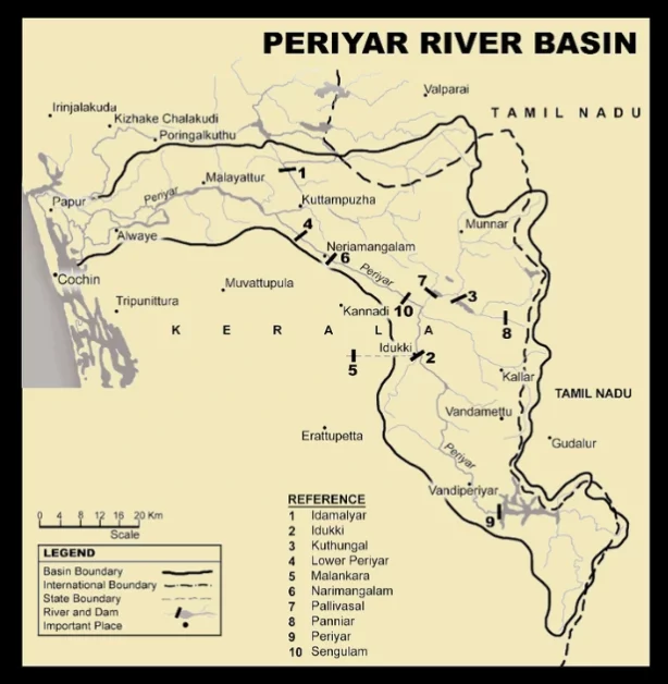
Tributaries of the Periyar River
The River is fed by several smaller streams and rivers, which are known as its tributaries. These tributaries can be classified into two groups based on which side of the Periyar River they have located: left-bank and right-bank tributaries.
| Left Bank Tributaries | Right Bank Tributaries |
|---|---|
| Mullayar River | Muthirapuzha River |
| Cheruthoni River | Edamala River |
| Perinjankutti River | Pamba River |
Left Bank Tributaries:
- Mullayar River: Originating in the Idukki district, the Mullayar River is a left-bank tributary of the Periyar River that flows through the Mullaperiyar Reserve Forest before joining the Periyar River near Kuttikkanam. It is an important source of water for irrigation and hydroelectric power generation.
- Cheruthoni River: Also originating in Idukki, the Cheruthoni River is a left-bank tributary of the Periyar River that is formed by the confluence of the Kuthiravattom and Kattappana Rivers. It flows through the Cheruthoni Dam before joining the Periyar River at Cheruthoni.
- Perinjankutti River: Originating in the Western Ghats, the Perinjankutti River is a left-bank tributary of the Periyar River that flows through the Periyar National Park before joining the Periyar River near Kalady. It is a perennial river that is fed by numerous smaller streams.
Right Bank Tributaries:
- Muthirapuzha River: Originating in the Anaimudi Hills, the Muthirapuzha River is a right-bank tributary of the Periyar River that flows through the Munnar region before joining the Periyar River at Moolamattam. It is a major source of water for irrigation and hydroelectric power generation.
- Edamala River: Originating in the Peerumedu Hills, the Edamala River is a right-bank tributary of the Periyar River that flows through the Edamalayar Reserve Forest before joining the Periyar River at Maniyarankudi. It is a perennial river that is fed by several smaller streams.
- Pamba River: Originating in the Western Ghats, the Pamba River is a right-bank tributary of the Periyar River that flows through the Pathanamthitta and Alappuzha districts before flowing into the Arabian Sea. It meets the Periyar River at Elanthikara and is an important source of water for agriculture and hydroelectric power generation.
While these dams have contributed significantly to the development of the region, they have also raised concerns over their environmental impact. The construction of dams has altered the natural flow of the river, affecting the health and quality of the ecosystem. The dams have also displaced local communities, who have been dependent on the river for their livelihoods.
Additionally, the Mullaperiyar Dam has been a source of tension between the governments of Kerala and Tamil Nadu due to safety concerns and the age of the dam.
Overall, the dams on this River are a testament to the region’s development and progress. However, their impact on the environment and local communities must be carefully managed to ensure the long-term sustainability of the river and its surrounding ecosystem.
Ecological importance of the Periyar River
The Periyar River and its surrounding ecosystem are home to a wide range of flora and fauna. The river basin is a vital part of the Western Ghats biodiversity hotspot and is home to many endemic and endangered species of plants and animals.
Further, the river supports a diverse range of aquatic life, including fish, crabs, and prawns. The surrounding forests are home to many species of birds, mammals, and reptiles, including the elusive Nilgiri tahr and the endangered lion-tailed macaque.
Historical & Cultural Significance of the Periyar River
The River has been a crucial source of livelihood for the local communities living in its basin. The river has played an essential role in the cultural and religious practices of the people, who consider it a sacred river.
The river has also been an essential trade route, connecting the hinterland with the coastal regions. The Periyar River has been an important part of the history of the region, with many ancient temples and monuments located on its banks.
Human Interventions & Environmental Concerns
The River has faced numerous environmental challenges over the years due to human interventions. The river has been subjected to pollution, encroachments, and sand mining, which have affected the health and quality of the river.
The construction of dams and hydroelectric power projects has also altered the natural flow of the river, leading to flooding, erosion, and loss of biodiversity. The encroachments on the river banks have also led to the displacement of the local communities, who are dependent on the river for their livelihoods.
Policy and Governance Issues for Periyar River Management
The conservation and management of the Periyar River have been the subject of intense debate and discussion among policymakers and environmentalists. The government has initiated several measures to protect the river, including the implementation of the Periyar River Conservation Plan and the establishment of the Periyar Foundation.
The government has also introduced measures to regulate sand mining, prevent encroachments, and promote sustainable tourism in the region. However, there is still a need for more significant efforts to ensure the long-term sustainability of the river and its ecosystem.
Conclusion
The Periyar River is one of the major rivers of Kerala and plays a crucial role in the social, cultural, and economic life of the region. It has a rich and diverse ecosystem and is home to numerous species of flora and fauna, including many endangered species. The river also serves as a source of water for irrigation, hydroelectric power generation, and domestic use.
However, it is facing several challenges due to anthropogenic activities such as deforestation, industrialization, and pollution. It is important to take steps to conserve and manage the Periyar River to ensure that its ecological and economic benefits can be sustained for future generations.
Thank You!
What is the total length of the Periyar River?
The Periyar River is a river located in the Indian state of Kerala. It is approximately 244 kilometers (152 miles) in length.
Where does the Periyar River originate?
The Periyar River originates from the Sivagiri peak in the Western Ghats mountain range in the Indian state of Kerala.
What is the Route of the Periyar River?
The Periyar River flows in a south-westerly direction from its source in the Sivagiri hills, and passes through the following towns and cities before flowing into the Arabian Sea near Kochi:
Sivagiri – Peerumedu – Vandiperiyar – Thekkady – Mullaperiyar – Periyar Lake – Periyar Wildlife Sanctuary – Kumily – Vallakadavu – Lower Periyar – Aluva – Eloor – Kochi
Related Links: