
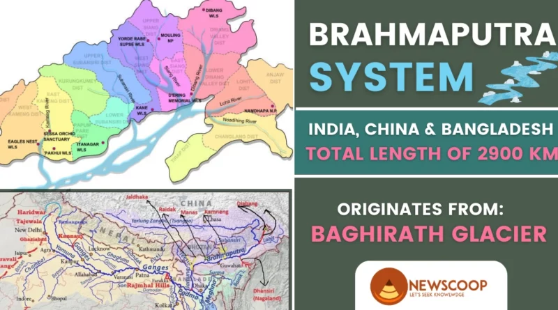
The Brahmaputra River System is a massive river system located in Asia, flowing through multiple countries and supporting millions of people. It originates in Tibet and flows through China, India, and Bangladesh, where it eventually empties into the Bay of Bengal. The river system is approximately 2,900 kilometers (1,800 miles) long and is the ninth-largest river in the world.
Further, the Brahmaputra River System is a vital lifeline for the people of the region, supporting agriculture, transportation, and energy production. Its importance to the region’s economy, culture, and environment cannot be overstated.
| Aspect | Brahmaputra River |
|---|---|
| Length | 2,900 km |
| Countries | China, India, Bangladesh |
| Origin | Angsi Glacier in the Himalayas (Tibet) |
| River Island | Majuli |
| Flow Direction | Eastward |
| Tributaries | Subansiri, Kameng, Manas, Dhansiri, Jia Bharali, Sonai, Teesta, Raidāk (Wangchu), Sankosh, Lohit, and more |
| Major Cities | Guwahati, Dibrugarh, Tezpur (India); Dhaka (Bangladesh) |
| Delta | Sundarbans Delta |
Physical Features of the Brahmaputra River System
The physical features of the Brahmaputra River system encompass its Himalayan origins, extensive length, numerous tributaries, expansive floodplains, and the formation of significant landforms such as the world’s largest river island, Majuli, presenting a captivating landscape for exploration.
Following are the most important facts about the Brahmaputra River:
- In Sanskrit, Brahmaputra means “son of Brahma“.
- The Brahmaputra River is approximately 2,900 km (1,800 miles) long.
- The river varies in width, ranging from 1 to 20 km (0.6 to 12.4 miles) in certain sections.
- The depth of the river also varies, with the deepest point recorded at approximately 125 meters (410 feet) near Guwahati in Assam.
- Kangchenjunga, which stands at 8,586 meters, is the highest peak within the Brahmaputra River basin.
- The Brahmaputra River has several major tributaries, including the Dibang, Lohit, Subansiri, Kameng, and Manas Rivers.
- The Dibang River contributes around 25% of the total water volume of the Brahmaputra River, while the Lohit and Subansiri Rivers contribute approximately 18% and 12%, respectively.
- The Kameng and Manas Rivers also contribute significant amounts of water to the river system.
- The Brahmaputra River has a highly seasonal flow, with the majority of water flowing during the monsoon season from June to September.
- The average annual discharge of the Brahmaputra River is approximately 19,500 cubic meters per second (m3/s).
- The total water volume of the Brahmaputra River is estimated to be around 580 cubic kilometers (140 cubic miles) per year.
Location & Source of Brahmaputra River
- The Brahmaputra River originates in the Baghirath glacier in the Kailash range near the Manasarovar lake in the north of the Himalayas in Tibet.
- The source is located at an altitude of around 5,000 meters (16,400 feet) above sea level.
- The river flows eastward through Tibet before turning south and crossing into India’s northeastern state of Arunachal Pradesh.
- The river is initially known as the Siang River in India.
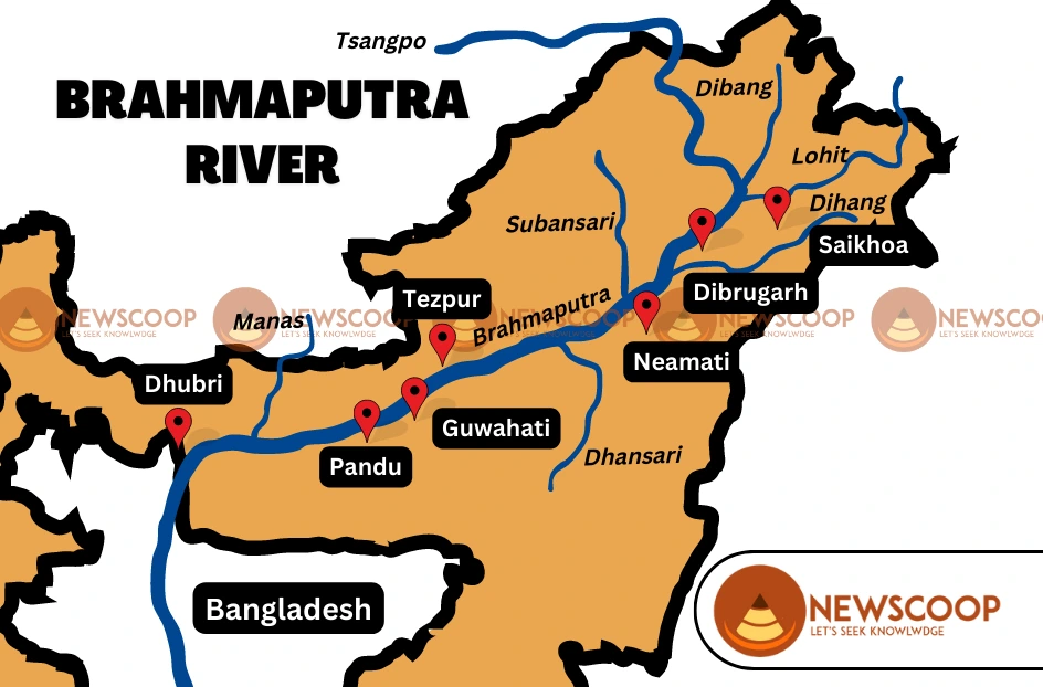
Course & Flow in India
- The Brahmaputra River flows towards the east in Tibet and then southwards, and southwestwards as it enters India, traversing a total distance of approximately 2900 km. Out of this distance, approximately:
- 1700 km is within Tibet
- 900 km is within India
- 300 km flows through Bangladesh.
- The Brahmaputra River is known as the Yarlung Zangbo River in Tibet and as the Tsangpo River in some parts of the region.
- As the Brahmaputra River flows through the Himalayas and into Arunachal Pradesh, it creates a deep gorge by cutting through the mountains near Namcha Barwa.
- When the Brahmaputra River enters India, it is known by the names Siang and Dihang.
- The Siang River flows through steep gorges and dense forests in Arunachal Pradesh before entering the plains of Assam.
- In Assam, the Siang River joins with the Dibang and the Lohit Rivers to form the Brahmaputra River.
- The Brahmaputra River flows through the states of Assam and Meghalaya in India before entering Bangladesh near Dhubri or Goal Para.
- In Bangladesh, the Brahmaputra River is known as the Jamuna River, and it joins with the Ganges and the Meghna Rivers before flowing into the Bay of Bengal.
- The course of the river is characterized by changing landscapes and diverse ecosystems, including high mountains, deep gorges, wetlands, and floodplains.
- The flow of the river is highly seasonal, with monsoon rains causing frequent floods in the river basin.
- The river is an important source of water and food for the people living in the region, and it has shaped the culture and economy of the countries it flows through.
Map of Brahmaputra River System
Major Cities on River
Here’s a list of major cities along the course of the Brahmaputra River:
- Guwahati (India)
- Dibrugarh (India)
- Tezpur (India)
- Jorhat (India)
- Silghat (India)
- Goalpara (India)
- Dhaka (Bangladesh)
- Jamalpur (Bangladesh)
Regions Drained by the Brahmaputra River System
The Brahmaputra River System is an extensive river network that drains a vast area encompassing several regions, including:
- The Himalayan Region East of Indo-Nepal Border
- South-Central Portion of the Tibetan Plateau Above the Ganga Basin
- South-Eastern Portion of Tibet
- Patkai-Bum Hills
- Northern Slopes of the Meghalaya Hills
- Assam Plains
- Northern Portion of Bangladesh
Tributaries of Brahmaputra River
The Brahmaputra River system is fed by numerous tributaries that originate from the eastern Himalayas and the Tibetan plateau. The tributaries are crucial to the overall flow and water volume of the Brahmaputra River and provide essential water resources to the region.
Left Bank Tributaries
- Siang River
- Dibang River
- Lohit River
- Burhi Dihing River
- Dhansiri River
- Kopili River
Right Bank Tributaries
- Subansiri River
- Kameng River
- Manas River
- Sankosh River
- Raidak River
- Teesta River
Dams on the Brahmaputra River & Tributaries
Here is a table listing the important dams in the Brahmaputra river system in India:
| Dam Name | River | Location |
|---|---|---|
| Subansiri Lower | Subansiri | Assam |
| Kameng | Kameng River | Arunachal Pradesh |
| Doyang | Doyang | Nagaland |
| Kopili | Kopili | Assam |
| NEEPCO | Dikrong | Arunachal Pradesh |
| North Karimganj | Barak | Assam |
| Karbi Langpi | Langpi Dehang | Assam |
The climate of the Brahmaputra River System
The Brahmaputra River System flows through diverse regions with varying climates. The upper reaches of the river in Tibet experience an arid climate with low precipitation levels.
In contrast, the lower reaches of the river in Assam and Bangladesh experience high levels of rainfall. This variation in climate is due to the river system flowing through different regions, including the arid Tibetan plateau, the humid subtropical climate of Assam, and the tropical climate of Bangladesh.
Weather Patterns
The weather patterns of the Brahmaputra River System are strongly influenced by the monsoon season. During the monsoon season, which typically lasts from June to September, the region experiences heavy rainfall and flooding.
The river and its tributaries often overflow their banks, causing widespread flooding and damage to crops and infrastructure. In addition to the monsoon season, the region also experiences cyclones and other weather events that can cause significant damage and loss of life.
Ecosystem & Biodiversity
Ecosystem: The Brahmaputra River System supports a rich and diverse ecosystem, with a wide range of flora and fauna. The river and its tributaries flow through several different types of ecosystems, including alpine meadows, forests, wetlands, and floodplains.
These different ecosystems support a range of plant and animal species and are essential for the survival of many local communities.
Biodiversity: The Brahmaputra River System is home to a diverse range of species, including many endangered and threatened species. The river and its tributaries support over 200 fish species, including the critically endangered Ganges River Dolphin and several species of catfish.
The region is also home to several large mammals, including the Indian Rhinoceros, Asian Elephant, and Bengal Tiger. Additionally, the river and its floodplains support a wide range of bird species, including several species of cranes and waterfowl.
Conclusion
In conclusion, the Brahmaputra River System is an important and significant river system in Asia, flowing through three different countries and supporting a diverse range of flora and fauna. The river and its tributaries support millions of people who rely on it for their livelihoods, including agriculture, fishing, and transportation.
However, the river system and its ecosystem are under threat from a range of factors, including climate change, pollution, habitat destruction, and overfishing. To ensure the sustainability of the river system and the well-being of the communities that depend on it, it is essential to take steps to address these threats and promote sustainable development practices.
Thank You!
What is the length of the Brahmaputra River?
The Brahmaputra River is approximately 2,900 kilometers long, out of which 1,700 kilometers are in Tibet, 900 kilometers are in India, and 300 kilometers are in Bangladesh.
What is the highest peak in the Brahmaputra River Basin?
Kangchenjunga is the highest peak in the Brahmaputra River Basin, standing at an elevation of 8,586 meters.
Which countries does the Brahmaputra River flow through?
The Brahmaputra River flows through China, India, and Bangladesh.
What are the tributaries of the Brahmaputra River?
The significant tributaries of the Brahmaputra River are the Subansiri River, Kameng River, Manas River, Dhansiri River, Teesta River, Raidāk River (also known as Wangchu or Wong River), Sankosh River, and Lohit River.
Related Links: