
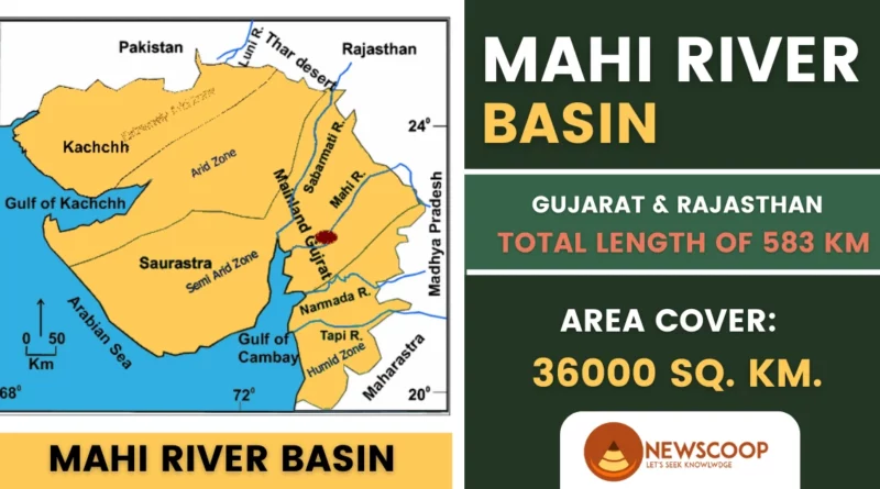
Mahi River is one of the major rivers in western India, located in the states of Gujarat and Rajasthan. The river originates from the Vindhya Range near the village of Bhopawar in Madhya Pradesh and flows for a distance of about 583 km before draining into the Arabian Sea. The river basin covers an area of about 36,000 square kilometers, and the river is a major source of water for irrigation, drinking, and industrial purposes in the region.3
The river flows through the districts of Panchmahal, Vadodara, Kheda, Anand, and Mahisagar in Gujarat, and Dungarpur and Banswara in Rajasthan. The river is also home to several important dams, such as the Mahi Bajaj Sagar Dam, the Kadana Dam, and the Panam Dam, which have significantly contributed to the irrigation and power generation in the region.
The Mahi River holds significant cultural and historical importance, as it has been mentioned in ancient Indian texts and is also associated with various mythological tales. The river also supports a diverse ecosystem of flora and fauna, making it an essential natural resource for the region.
| River | Mahi River |
| Location | Western India |
| States | Madhya Pradesh, Rajasthan, Gujarat |
| Length | 583 km |
| Source | Amjhera Village, MP |
| Mouth | Gulf of Khambhat |
| Tributaries | Som River, Anas River, Vakal River, etc. |
| Major Cities | Dhar, Pali, Anand, Vadodara, etc. |
| Bridges | In Dhar, Vadodara, and Anand |
| Dam | Mahi Bajaj Sagar Dam, Kadana Dam |
Geographical Features of the Mahi River System
Here are some important facts about the Mahi River in points:
- The Mahi River is one of the significant rivers in western India and originates from the Kanta Hills of Vindhya Range near Bhopawar village in Madhya Pradesh.
- It flows for about 583 km and empties into the Arabian Sea.
- The river basin spans about 36,000 sq km and covers parts of Gujarat and Rajasthan.
- It passes through several districts of Gujarat, including Panchmahal, Vadodara, Kheda, Anand, and Mahisagar, as well as the Dungarpur and Banswara districts of Rajasthan.
- It is fed by tributaries, including the Som, Anas, and Panam Rivers.
- The river flow is intermittent, carrying most of its water during the monsoon season (June to September).
- The river has several important dams such as the Mahi Bajaj Sagar Dam, Kadana Dam, and Panam Dam.
- The river’s course has several rocky stretches, rapids, and waterfalls, and it has formed canyons and gorges such as the Kadia Dungar Gorge and the Pawai Gorge.
- The catchment area of the river comprises primarily granite, gneiss, and schist rocks, contributing to its unique geology and hydrology.
- The river supports a diverse ecosystem of flora and fauna, including several endangered and threatened species such as the Indian Skimmer and Gharial.
Origin of Mahi River
The Mahi River originates from the northern slopes of the Vindhyas at an altitude of around 500 meters near the village of Bhopawar in the Sardarpur tehsil of the Dhar district in Madhya Pradesh, India. It flows southwest before eventually reaching its mouth at the Gulf of Khambhat.
Map of Mahi River

Major Cities Along the Mahi River
The Mahi River passes through several major cities along its course:
- Dhar
- Ratlam
- Banswara
- Jhalawar
- Baran
- Pali
- Anand
- Vadodara
Historical Features of the Mahi River
The Mahi River has played an important role in the history and culture of the region it flows through. The river has been mentioned in several ancient Hindu scriptures such as the Rigveda and the Mahabharata. This highlights the river’s cultural and religious significance for the people living in the region.
The river has been an important trade route since ancient times, connecting the port city of Khambhat (Cambay) to the interior regions of western India. The river facilitated trade and commerce in the region, and it was a major contributor to the economic growth of the region.
Further, it has several historical and archaeological sites along its course, including the ruins of the ancient city of Champaner near the present-day city of Vadodara. Champaner was an important city during the medieval period, and its ruins are now a UNESCO World Heritage Site. This demonstrates the river’s role in shaping the region’s urban development and history.
Moreover, the river was also the site of several battles during the 16th and 17th centuries, including the Battle of Khambhat between the Mughal Empire and the Portuguese in 1631. These battles highlight the river’s strategic importance in the region.
The river has several historical temples and shrines along its course, including the Mahakali Temple in Dabhoi, the Raj Rajeshwari Temple in Vadodara, and the Dattatreya Temple in Dabhoi. These temples and shrines are an important part of the region’s religious and cultural heritage.
The river’s banks have been home to several ancient settlements and civilizations, including the Indus Valley Civilization and the Harappan Civilization. This demonstrates the river’s significance in shaping the region’s ancient history and development.
In addition to this, the River has been a source of inspiration for several artists, poets, and writers, including the famous Gujarati poet Narmad who composed several poems dedicated to the river. This highlights the river’s cultural significance as a source of inspiration for the region’s artistic and literary traditions.
List of Dams on the Mahi River
There are several dams built on the Mahi River for irrigation, hydroelectricity generation, and other purposes. Here are some of the major dams on the Mahi River:
- Mahi Bajaj Sagar Dam: Located in the Panchmahal district of Gujarat, it is one of the largest dams on the Mahi River. The dam was built in 1961 and provides irrigation to about 70,000 hectares of land in the region. It also generates hydroelectric power with a capacity of 240 MW.
- Kadana Dam: Located in the Sabarkantha district of Gujarat, it was built in 1979 and has a capacity of 308.22 million cubic meters. It provides irrigation to about 28,000 hectares of land in the region.
- Wanakbori Dam: Located in the Kheda district of Gujarat, it was built in 1979 and has a capacity of 920 million cubic meters. It provides irrigation to about 22,000 hectares of land in the region and generates hydroelectric power with a capacity of 1,470 MW.
- Panam Dam: Located in the Dahod district of Gujarat, it was built in 1983 and has a capacity of 88.77 million cubic meters. It provides irrigation to about 3,500 hectares of land in the region.
- Mahi Canal Head Regulator: Located in the Vadodara district of Gujarat, it was built in 1970 and provides irrigation to about 18,000 hectares of land in the region.
| Dam Name | Location |
|---|---|
| Mahi Bajaj Sagar Dam | Panchmahal, Gujarat |
| Kadana Dam | Sabarkantha, Gujarat |
| Wanakbori Dam | Kheda, Gujarat |
| Panam Dam | Dahod, Gujarat |
| Mahi Canal Head Regulator | Vadodara, Gujarat |
These dams have played a significant role in the development of the region by providing water for irrigation, generating hydroelectric power, and serving other purposes. However, they have also led to several ecological and environmental issues such as the displacement of local communities, loss of biodiversity, and altered riverine ecosystems.
Tributaries of the Mahi River
The Mahi River, one of the major rivers in western India, is fed by several tributaries along its course. Some of the major tributaries of the Mahi River include the Anas River, Panam River, Meshwo River, Orsang River, and Sukhi River.
Left Bank Tributaries
- Panam River: The Panam River is a left-bank tributary of the Mahi River, which originates in the Aravalli Range near Himmatnagar in Gujarat. It flows for about 94 kilometers before joining the Mahi River near Lunawada in Gujarat.
- Anas River: The Anas River is another left-bank tributary of the Mahi River, which originates in the Aravalli Range near Idar in Gujarat. It flows for about 240 kilometers before joining the Mahi River near Kheda in Gujarat.
Right Bank Tributaries
- Meshwo River: The Meshwo River is a right-bank tributary of the Mahi River, which originates in the hills near Dharampur in Gujarat. It flows for about 100 kilometers before joining the Mahi River near Godhra in Gujarat.
- Orsang River: The Orsang River is a major right-bank tributary of the Mahi River, which originates in the Satpura Range near Khandwa in Madhya Pradesh. It flows for about 450 kilometers before joining the Mahi River near Tilakwada in Gujarat.
Flora & Fauna of Mahi River
The Mahi River and its surrounding ecosystem are home to a diverse range of flora and fauna. Here are some of the important species:
Flora:
- The riverbanks and surrounding areas are home to various types of trees such as teak, neem, mango, banyan, tamarind, and pipal.
- The river also supports various aquatic plants such as water hyacinth, lotus, and water lilies.
- The wetlands near the riverbanks provide habitat for several types of grasses, sedges, and other wetland plants.
Fauna:
- The river is home to several fish species such as catfish, carp, mahseer, and rohu, making it an important fishing ground.
- The river also supports various other aquatic animals such as turtles, crocodiles, and otters.
- The wetlands surrounding the riverbanks provide a habitat for several bird species such as egrets, herons, kingfishers, and cormorants.
- The surrounding forests and grasslands provide a habitat for several mammal species such as wolves, jackals, foxes, hyenas, and wild boars.
- The river also supports several reptile and amphibian species such as snakes, lizards, frogs, and toads.
Challenges & Conservation of Mahi River
The Mahi River, like many other rivers in India, faces a number of challenges related to its conservation and management. These challenges include:
- Pollution: The Mahi River is heavily polluted due to the discharge of untreated industrial and domestic effluents, agricultural runoff, and other anthropogenic activities. This has led to a decline in water quality, loss of aquatic biodiversity, and a threat to public health.
- Deforestation and soil erosion: Deforestation and soil erosion in the catchment area of the Mahi River have led to increased sedimentation and reduced water holding capacity, affecting both the quantity and quality of water available in the river.
- Dams and water diversion: Dams and water diversion structures built on the Mahi River and its tributaries for irrigation, drinking water supply, and hydropower generation have altered the river’s natural flow regime, affecting the ecology of the river and its floodplain.
- Climate change: Climate change is expected to have significant impacts on the Mahi River basin, including changes in precipitation patterns, increased frequency and intensity of extreme weather events, and changes in temperature regimes, which could affect the river’s hydrology and ecosystem.
To address these challenges and conserve the Mahi River, several measures have been taken, including:
- Pollution control: The government and non-governmental organizations have taken steps to control pollution in the Mahi River by setting up effluent treatment plants, promoting sustainable agriculture practices, and creating awareness among the public.
- Afforestation and soil conservation: Afforestation and soil conservation measures have been taken in the catchment area of the Mahi River to reduce soil erosion and increase water holding capacity.
- Restoration of floodplains and wetlands: Efforts have been made to restore the floodplains and wetlands of the Mahi River, which provide important habitats for aquatic and terrestrial biodiversity.
- Water conservation: Various water conservation measures, such as rainwater harvesting, have been promoted to ensure the efficient use of water resources in the Mahi River basin.
- Climate change adaptation: Strategies for climate change adaptation, such as developing drought-resistant crops, have been implemented to mitigate the potential impacts of climate change on the Mahi River and its ecosystem.
Overall, conservation and management of the Mahi River require a multi-stakeholder approach, involving government agencies, civil society organizations, and local communities, to ensure sustainable use of its water resources and protection of its ecological integrity.
Conclusion
The Mahi River is a significant river in the Indian state of Gujarat, with a rich cultural, historical, and ecological legacy. The river has witnessed the rise and fall of several empires and has been an important source of livelihood for the communities living along its banks.
Despite its significance, the Mahi River is facing several challenges related to its conservation and management, including pollution, deforestation, alteration of its natural flow regime, and potential impacts of climate change. However, efforts are being made to address these challenges through pollution control measures, afforestation and soil conservation, restoration of floodplains and wetlands, water conservation measures, and climate change adaptation strategies.
Thank You!
FAQs
What is the total length of the Mahi River?
The Mahi River is approximately 583 kilometers long, originating in the western Indian state of Madhya Pradesh and flowing through Rajasthan and Gujarat before emptying into the Arabian Sea.
What are the tributaries of the Mahi River?
The Mahi River has several tributaries, both on its left and right banks. Some of the major tributaries of the Mahi River include the Anas River, the Panam River, the Meshwo River, and the Kharicut River.
Where does the Mahi River originate from?
The Mahi River originates from the northern slopes of the Vindhyas near the village of Bhopawar in the Sardarpur tehsil of the Dhar district in Madhya Pradesh, India.
Mahi River flows through which states?
Mahi River flows through Madhya Pradesh, Rajasthan, and Gujarat.
Related Links: